This is the park, children are swinging here and tourists are coming and eating food. The Ganges flowed here till a few years ago. This scene is of Vidur Kuti of Bijnor district of UP. Vidur Park has also been built. Ganga shifted to one and a half kilometers west of this Vidur Kuti. With
,
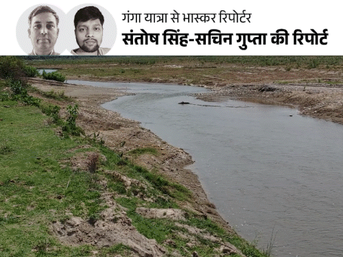
‘Dainik Bhaskar’ has come out on a 1450 km long ‘Ganga Yatra’ in Uttar Pradesh. The yatra started with the border Bhaguwala (Bijnor) of Uttarakhand -UP. On the first day of the yatra, today we will tell about 300 kilometers of Ganga from Bhaguwala to Hastinapur, Read this special report…

The Ganges in Bijnor district on Uttarakhand-UP border has been reduced to this way.
Mining in Uttarakhand, JCB running on UP border… ..
During our Ganga trip, we first reached Bhaguwala in Bijnor. This is the place where Ganga enters UP via Uttarakhand. This point is about 50 km from Bijnor headquarters and about 30 km from Haridwar in dense forests. We reached this place while walking on high, low, thunderstorms in several kilometers of Khadar area. Here Ganga is coming in two streams. One stream is about 200 meters wide and the other is like a drain. A JCB machine is running towards the Uttarakhand border.

Machines were mining on Bhaguwala towards Uttarakhand. We flew a drone in about 3 km khadar, then this scene could be captured.
We saw that sand mining is happening here. There is a distance of about 6 kilometers between Bhaguwala village and this point. This is an area of 6 km Ganga Khadar area, where all trees and plants are grown. There are high plains. Local people say – Sometimes this Ganges flowed from this village. With time, Ganga got away from the village. The main reason for the changed stream is sand mining.
Bijnor: Ganga reaches one and a half kilometers from Vidur Kuti
After seeing the condition here, we reached Vidur Kuti in Bijnor district, about 64 km away, traveling along the Ganges. We were told that the Ganges flows in Vidur Kuti, but nothing like this was found. A stream of Ganga was seen on walking about one and a half kilometers west. The width of this stream will be about 100 meters. After this, there are sandy islands, on which we found the crop flowing. The main stream of Ganga is flowing after crossing this island.

There is an ancient and historical temple of Mahatma Vidur here. We met the chief priest of the temple Anuj Kumar Sharma. They say – Our family has been overseeing this temple for more than 40 years. I am a third generation serviceman. I remember a lot, when the Ganges river flowed from the temple. There was a pucca ghat to bathe in the Ganges on Vidur Kuti, which also had some stairs. Now the Ganges has gone away in the last 20 years. In such a situation, the existence of Pucca Ghat is over. Vidur Park has now been replaced by him. There are swings etc. for children to play.
Anuj Sharma says – We are trying to bring Ganga again on Vidur Kuti. Recently, a delegation met CM Yogi Adityanath. He has assured to do concrete work in this direction. After this, a team has come to Vidur Kuti and surveyed. We hope that with the efforts of the government, Ganga will then flow with Vidur Kuti. For this, the Ganges stream has to be folded from behind several kilometers behind and to Vidur Kuti.
The priest of the temple told – This place is mythological and Mahabharata period. Here Mahatma Vidur resided by making a hut. Lord Krishna left Duryodhana’s nuts and ate the greens of Bathua, Vidur’s house. Former President Rajendra Prasad has also come to this temple.

Ganga where the deepest, 5-5 feet high sand island
We reached Chaudhary Charan Singh Ganga Barrage, about 13 km from Vidur Kuti. It is built on the Bijnor -Merath highway. The length of the barrage bridge is about one kilometer. Standing on the bridge and seeing a look, the island of sand is clearly visible in the Ganges. In many places, the height of these islands is about five feet. This situation is when Ganga is considered to be the most depth on the barrage itself. We asked many sailors because of the formation of an island on the barrage.

Sandy islands are seen far and wide in the Ganges in Hastinapur near Meerut.
They say- A second bridge is being built above the Ganges, about one kilometer from the Ganges barrage. Right now the work of making the pillar of the bridge is going on. Because of this, the stream of Ganga has been turned, so that there is no hindrance in the work. It is due to turning the stream that the island has been formed in the Ganges on the barrage.
Special campaign for people along the Ganges
On the banks of the Bijnor Ganga, we got Jalaj Coordinator Pankaj Kumar. Under the Namami Gange project, the work of cleaning the Ganges goes on. Under this, Jalaj program has also been run.
Pankaj Kumar said – We have conducted awareness campaigns several times in the villages adjacent to the Ganges in Bijnor, Muzaffarnagar, Meerut district. During this time, the villagers tell that they should not put dirt in the Ganges. Do not catch aquatic organisms. Oath or resolution programs are also organized to save the Ganges. The effect of this campaign is also visible. People are now very aware of the Ganges.
Hastinapur: Karna Ghat on which Ganga flowed, now 6 km away
We reached Hastinapur in Meerut, about 60 km from Bijnor barrage in the villages along the Ganges. Here the Ganges river is flowing from behind in two streams. The width is so low that the Ganges is flowing only under the bridge. Here too, there are wide sand island in the Ganges. The distance of Hastinapur town from this bridge is more than 5 kilometers.
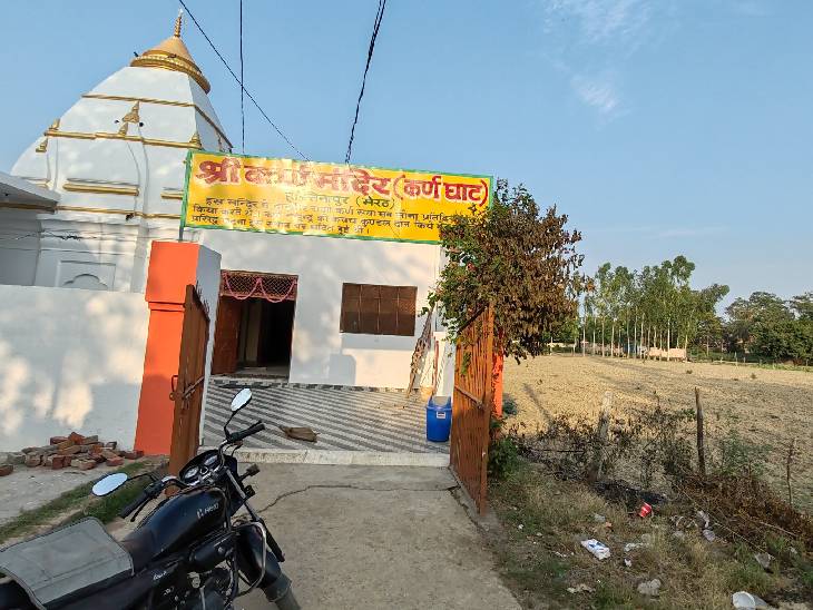
This is the Karna Ghat of Hastinapur. Sometimes the Ganges flowed here. Now Ganga has gone far away from here.
The temple of Danveer Karna was found as soon as he entered Hastinapur. There is a board on the temple. It is written on it – ‘Danveer king Karna used to donate gold every day in this temple. Karna donated armor to Indra. This famous incident took place at this place. This place on the board on the temple is shown as Karna Ghat.
Swami Shankar Dev, the priest of Sri Karna Temple, said- Karna Ghat means that once the Ganga Ghat flowed here. That is why this place must have been known as Karna Ghat. But, today the Ganges is flowing more than 7–8 kilometers from here. I have been serving this temple for the last 10 years. I have seen the Ganges till today only during the floods near the temple. Apart from floods, this land is cultivated on the rest of the days. Currently farming is also being done.

Study Report: Ganges rotation and width decreasing
Between 1958 and 1972, the US agency CIA took around 8,000 satellite pictures of the Ganges Basin. On the basis of these pictures, work started on Namami Gange project with the Survey of India. The pictures of that time were matched with the pictures of the year -2018. This shows that the pattern of Ganga’s flow has changed. Somewhere the flow of Ganges decreases and somewhere has increased. River rotation is ending. There has been a significant decrease in width. The reason for this is change in environment and encroachment on the Ganges.

This satellite picture is from Bijnor. It clearly shows how the width of the Ganges has reduced.
Regarding this report, Piyush Gupta, engineer of Namami Gange project, said – In 1965, the river bar i.e. the flow of the river in Haridwar was 17.85 sq km, which has now come down to 6.67 square kilometers now. The satellite image shows that the area of Ganga Cachar in Bijnor has increased from 4 square kilometers to 9 square kilometers.
Sand mining has increased in the Ganges. While the flowing edge has come down from 38 square kilometers to 15 square kilometers. That is, 23 square kilometers have decreased. A United Nation (UN) report also states that the Himalayas are melting rapidly due to climate change. In such a situation, if concrete steps are not taken, then the Ganges can dry up to 2050. This report is very worrying.


,
Read this news too …
Who was the Rohini who accused Nagina MP?: Amid the pain received from Chandrashekhar, the Puri’s PhD was up to suicide.

Rohini Ghawari, who accused Nagina from Azad Samaj Party MP Chandrashekhar Azad, says that I was in a lot of depression while writing PhD’s thesis. In 2023, even suicide was done. Who is Rohini Ghawari who questioned the political life and character of Chandrashekhar, who agitated from the road to the Parliament? Read full news